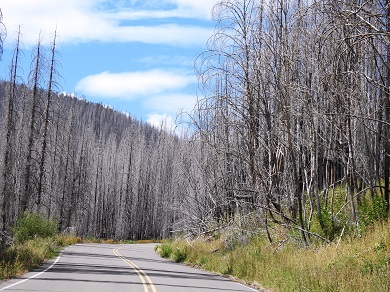
Prescribed fires are center of discussions
In 2023 Oregon has seen 628 fires, so far, burning 63,104 acres. Of those, 85 fires were started by lightning down from an average of 181. It’s the other 543 fires that are on the increase from 481 average over 10 years that are human caused and concerning.
SB 762 (2021) passed as the Landscape Resiliency Program (LRP) to improve forest restoration and set up landscape-scale projects that reduce wildfire risk on both public and private forestlands. The bill has been criticized over the Wildfire Maps producing a backlash. However, the appropriated $20 million also funded the placement of 20 more SensORs to monitor air quality from wildfires, and to treat 210,734 acres in the four highest expected net value change (eNVC) risk classes by the end of 2021-2023 biennium.
The Landscape Resilience Program Final Report concluded that the projects exceeded the expectation treating 211,914 acres. To date, there are no wildfires in the treated areas.
The most discussed part of the LRP are the three projects involved in prescribed fire (Rx) work, totaling 6,325 acres. The report says, “when Rx was completed, the fuel model changed, resulting in a less fire prone site, reduced fire risk, and decreasing potential fire intensity limiting severity.â€
Timber owners fear ODF may be forced to burn profitable resources if the Western Oregon Habitat Conservation Plan (HCP) is adopted. They are linking Rx to the proposed HCP if there is a
decrease in timber harvest by 50 percent. The National Forest Service (NFS) timber sales tied up in courts since 1970, lack of revenue from harvesting, and lack of funding by Congress has them suspecting that the larger fires may be creatively used as prescribed fire burns. Others site a federal agent as saying the way government works is to make NFS more influential by exploiting wildfires and growing the need to employ more firefighters and equipment to grow the agency.
A D V E R T I S E M E N T

A D V E R T I S E M E N T
Out of the 24 current fires in Oregon, there are currently five large fires. A complete list can be found on
Oregon Fires and Hotspots Dashboard. The five large fire areas to avoid:
- Flat Fire – located 2 miles SE of Agness, Oregon. This fire started on July 15 on the Rogue-Siskyou National Forest and is currently the largest fire in the state at 33,817 acres with 47% containment. It is burning in extremely difficult terrain and very dry fuels, which means this fire will remain on the landscape throughout the summer months. ODF continues to work with USFS and CFPA to manage the fire and protect high-risk values.
- Pricebord Fire – located 9 miles E of Junction City, Oregon. This fire started August 4, and has burned 310 acres and is 75% contained. This was an incredible catch, one of the best this year for ODF, made possible through the combination of ODF resources, local landowner efforts, Linn and Lane County fire departments, and OSFM. The fire is currently in the mop-up stage.
- Bedrock Fire – located 27 miles SE of Eugene, this fire started on July 22 and has burned 15,178 acres on the Willamette National Forest. Bedrock might be a case against prescribed burns. It started on the edge of a burn two years ago and moved fast through the older burn. Lightning started a second fire on the south edge at Gayles Creek, which the crew was told to let burn. Bedrock fire is now progressing north toward private land. Landowners and ODF staff have been engaged for weeks in an attempt to keep the fire off private ownership, however, due to difficult terrain and associated safety concerns, some private land will be burned. ODF personnel have been inserted into the IMT to ensure private land values at risk remain a top priority.
- Wiley Creek Fire – located 9 miles E of Sweet Home, Oregon. This fire started on August 7 on USFS ownership and is currently 220 acres and 5% contained. Unfortunately, the fire has spread onto approximately 10 acres of ODF protected land. Evacuation notices and road, trail, and area closures remain in place. A significant airshow with helicopters, water scooping, and retardant dropping aircraft was critical in reducing the spread rate of this fire and allow firefighters to establish fire lines quickly and safely. A robust Type 3 IMT is in place and making great progress through utilization of dozer and handline to surround the fire while resources begin the mop-up of hotspots. ODF remains confident this fire will remain in its current footprint with decreasing smoke impacts and fire activity alleviating some of the local concerns.
- Lookout Fire – located 4 miles northeast of McKenzie Bridge, Oregon. This fire was caused by lightning from a storm that moved through the area on August 5 and is currently 25 acres and 0% contained. This is a USFS fire in rugged land and roadless areas on Lookout Mountain, which delayed response giving it a big head start. Active fire behavior has prompted evacuation notices and threat to structures. It is ODF’s biggest concern due to a potential push toward Blue River through the combination of terrain aligned with east winds. USFS has a Type 3 IMT on the fire currently but has a Type 2 team incoming to take over management of the fire.
The Oregon Department of Forestry worked towards a shared stewardship approach to the LRP for implementing land management that improves community resilience against wildfires. However, resilience has different priorities when the community depends on timber for their necessities.
--Donna Bleiler| Post Date: 2023-08-17 09:43:21 | Last Update: 2023-08-17 17:01:00 |


